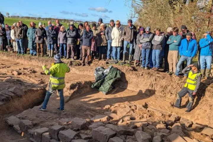
A once-in-a-generation discovery has brought new excitement to the study of Roman Britain, as volunteers working in Drumburgh, Cumbria, uncovered a previously lost section of Hadrian’s Wall.
The find, made during a three-week dig about ten miles from Carlisle, has been described as “the only visible bit” of the almost 2,000-year-old Roman structure to the west of the city.
Archaeologist Mark Graham, of the not-for-profit firm Grampus and Heritage Training, called it “a once-in-a-generation discovery”, confirming the accuracy of earlier geophysical surveys that had hinted at the wall’s location.
“Wall like this has not been seen here in our lifetime,” said Mr Graham. “When you put a trench in the ground, especially at a protected monument, you feel like you’ve got one shot at it and that was our shot to find the wall.”
“We weren’t expecting to find stone in the ground because it was all later recycled, so to even find a course of the wall was enough, but then to find a stone wall four courses high is just incredible,” he explained.
The discovery has stirred interest far beyond the archaeological community. More than 250 people attended an open day to view the unearthed section, eager to witness the long-hidden structure for themselves.
“We want local people to see it,” Mr Graham said. “Also, people in the village are often asked by walkers where the wall is. Of course, there was never anything to see. Now at least we can say it is there.”
Hadrian’s Wall, begun in AD 122 during the reign of Emperor Hadrian, stretched 73 miles from Wallsend on the River Tyne to Bowness-on-Solway. Built as a defensive fortification for the Roman province of Britannia, it marked the northern frontier of the empire and stood as a formidable symbol of Roman power.
The wall was constructed primarily of stone, with large ditches in front and behind, and was reinforced by forts, milecastles, and turrets manned by Roman soldiers. It not only served as a military barrier but also functioned as a customs checkpoint, regulating trade and movement across the frontier.
Almost all the standing masonry of Hadrian’s Wall was removed in early modern times, the stone repurposed for roads, farmhouses, and other local buildings. While the central, hilly sections of the wall still show traces of its original structure, much of the lower-lying terrain has long appeared barren of remains.
The newly revealed section at Drumburgh therefore represents an extraordinary survival, offering a rare physical connection to the western reach of the wall’s path.
The route of Hadrian’s Wall roughly followed the line of the earlier Roman road known as the Stanegate, linking Corbridge on the River Tyne to Carlisle on the River Eden. It passed through the rugged Whin Sill escarpment before descending toward the Solway Firth. Beyond Bowness-on-Solway, the defensive network continued along the Cumbrian coast, with smaller forts and milefortlets extending as far as Risehow near Maryport.
Hadrian’s Wall is widely regarded to have defined the borders and extent of the Roman world. In the Historia Augusta it says, “(Hadrian) was the first to build a wall, eighty miles long, to separate the Romans from the barbarians.”
The wall also exerted control over movement, with crossings limited to its gates, where the Romans could monitor, permit, or tax traffic. For nearly three centuries, until the end of Roman rule in Britain in AD 410, the wall represented a physical and psychological division between empire and wilderness, civilisation and chaos.
The symbolic power of Hadrian’s Wall has long endured. Some scholars have suggested that its gleaming, whitewashed surface once reflected sunlight for miles, a shining declaration of Rome’s might to anyone approaching from the north. British archaeologist Neil Faulkner described it as “as much a propaganda statement as a functional facility.”
With the wall now clearly visible, it offers a visible connection to an ancient era of Britain’s past